history Filed 04 · 03 15 min WR-FCT-002 ERASED thread
CLEARANCE
Black Bottom and Paradise Valley did not disappear. They were cleared through policy, plans, signatures, and asphalt.
Detroit's clean word for taking a Black neighborhood
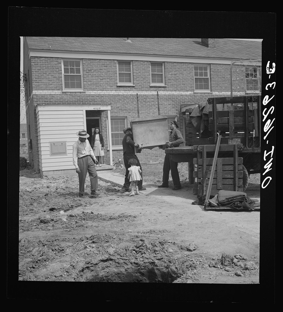
Every new file, the day it is filed.
The backhoe idles before the engine even roars. Brick dust hangs in the morning air. It mixes with the smell of frying perch drifting from a kitchen window and the sharp sweetness of hair tonic leaking from a barbershop door that will not open much longer. A city worker tapes a NOTICE OF CONDEMNATION to the frame of a jazz club. The neon still glows faint blue from the night before. This is how clearance begins. Not with shouting. With paperwork.
Black Bottom and Paradise Valley did not disappear because time passed or buildings aged. They were cleared through policy. Plans. Signatures. Asphalt. The language of improvement became the instrument of removal.
DENIED examined the stamp that makes harm permanent. This file steps earlier in the machine. CLEARANCE. Because once a neighborhood is cleared, the people who built it cannot even ask for what was owed.
Picture Black Bottom on a humid summer night. Laundry lines stretch across narrow yards. Two boys sprint between them while their mother calls from the porch. Domino tiles crack against wooden tables. Someone laughs loud enough to carry across the block. Around the corner, Paradise Valley glows. Neon hums above the Club Harlem. A barber sweeps hair into a dustpan while the man in the chair argues about last weekend’s fight. Onstage, Billie Holiday bends a note until the room forgets to breathe. This was not a myth.
By 1942 Black Bottom and Paradise Valley held more than 300 Black-owned businesses. Restaurants. Tailors. Beauty salons. Theaters. Music clubs. An ecosystem where money and memory moved in the same direction. Detroit’s white neighborhoods might have closed their doors. Black Detroit built its own hallway. Prosperity does something dangerous. It creates options. And systems built on containment do not like options.
Clearance never starts with demolition. It starts with diagnosis. First come the covenants that restrict where Black families can live. Then the loans that never arrive. Then the city services that quietly disappear. Buildings age. Streets crack. Overcrowding spreads through blocks where people were forced to concentrate. Then the city returns with a clipboard.
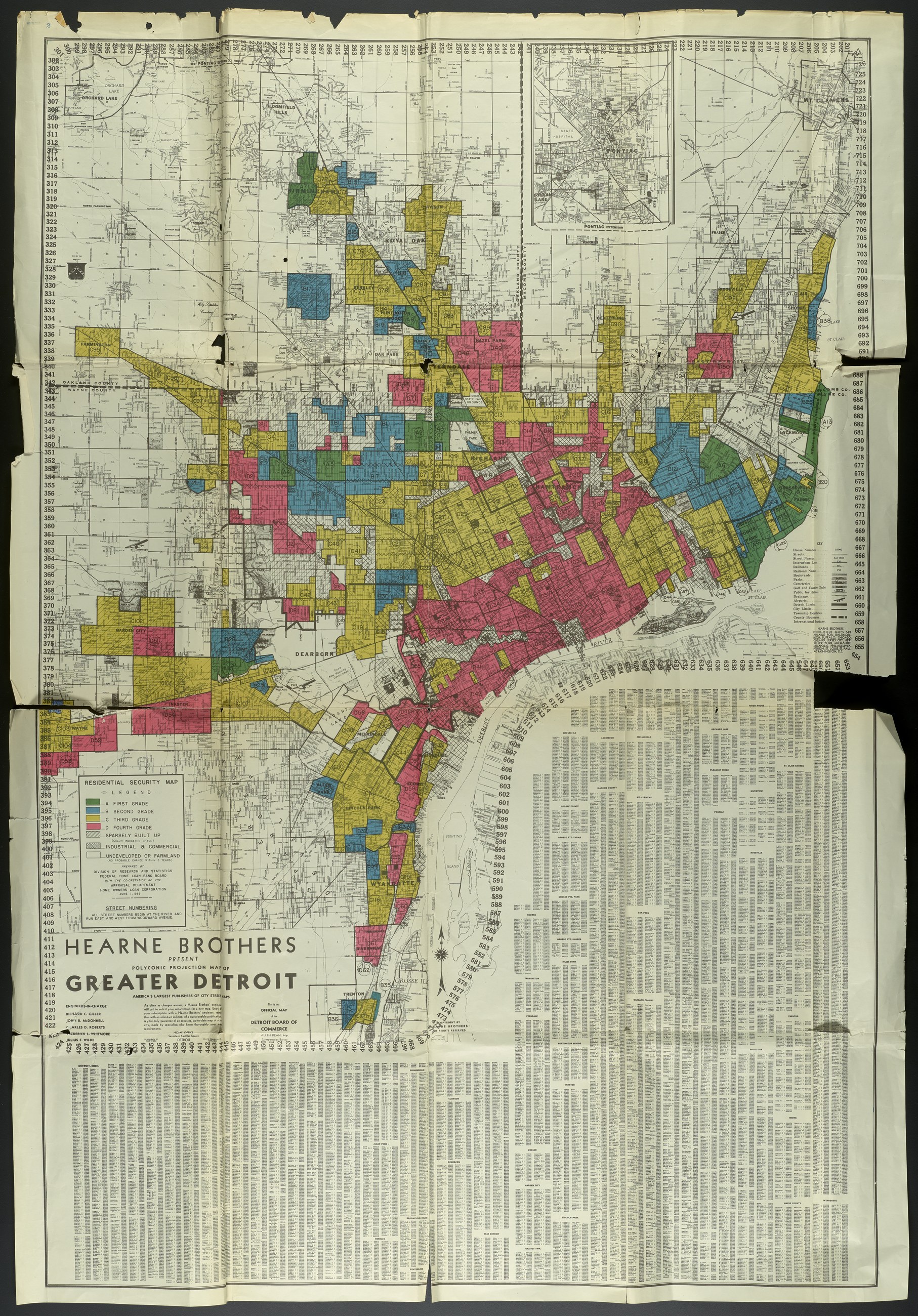
The map is not a metaphor. Residential Security Map of Greater Detroit, June 1939. Prepared by the Division of Research and Statistics, Federal Home Loan Bank Board, with the co-operation of the Appraisal Department, Home Owners’ Loan Corporation. Base map: Hearne Brothers, Detroit. Record Group 195, City Survey Files, National Archives, file unit NAID 354638226, image 1 of 265. Access: Unrestricted. Use: Unrestricted.
Black families were restricted to an increasingly overcrowded Black Bottom. Then punished for the crowding. That is not incompetence. That is choreography. Blight becomes the justification. Clearance becomes the cure.
The federal appraisers graded neighborhoods, among other things, by who lived in them, and they wrote it down on a printed form that has a blank for it.
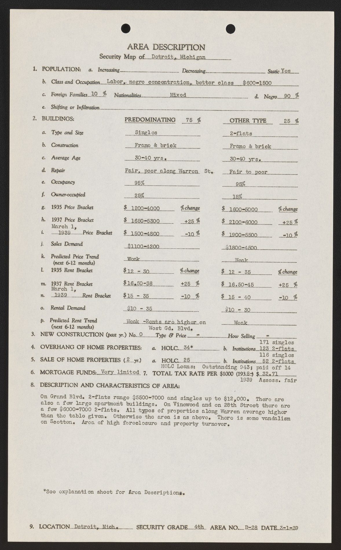
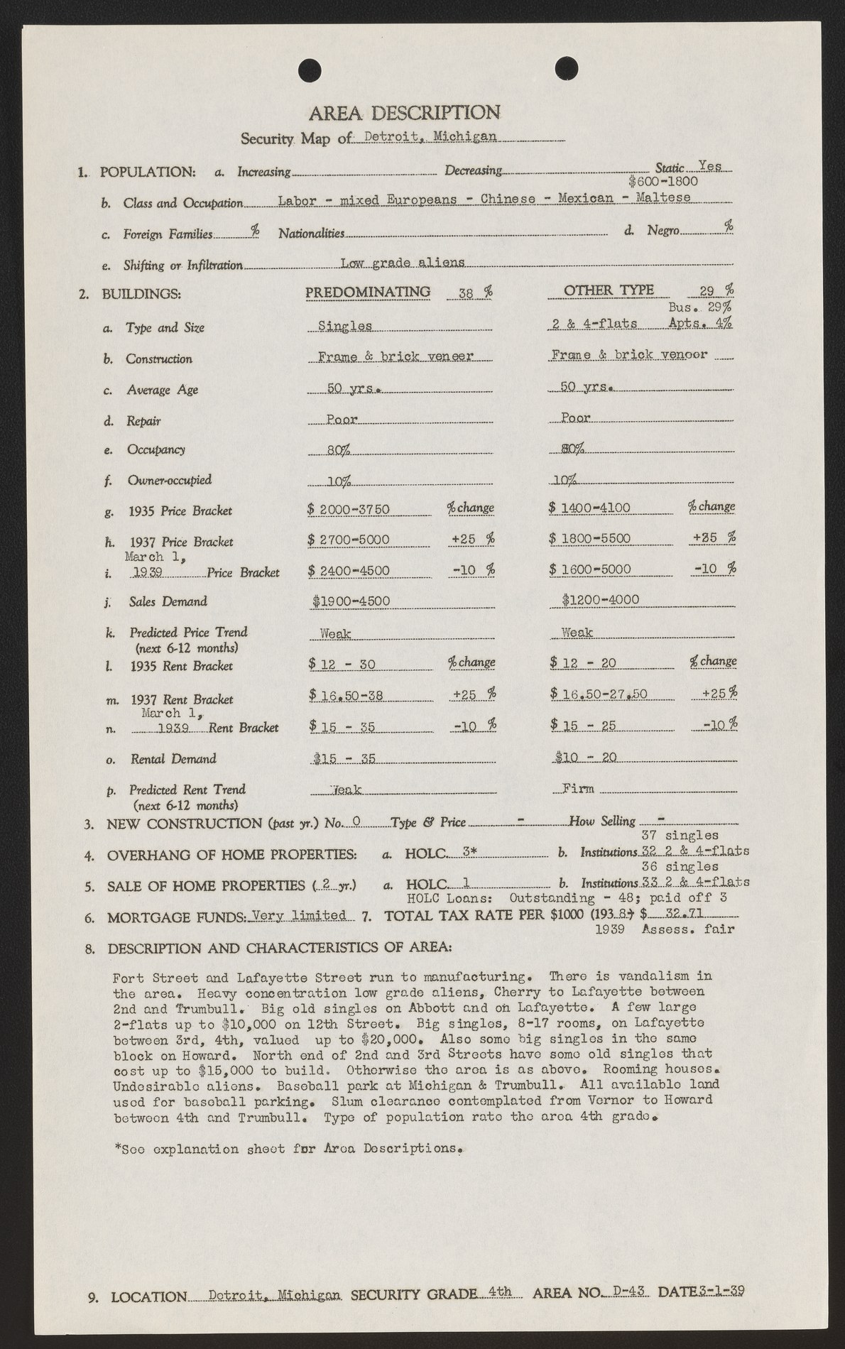
Left: Area D-28. The form’s printed field 1(d) reads “Negro ____%”. The form reads 90, typed. The grade is 4th, the lowest there is. Right: Area D-43, the same day. “Slum clearance contemplated from Vernor to Howard between 4th and Trumbull. Type of population rate the area 4th grade.” Neither area is Black Bottom: D-28 is on the west side, and D-43 lies west of downtown. Both: Home Owners’ Loan Corporation, March 1, 1939. RG 195, National Archives, NAID 354638226. Access and use, unrestricted.
Read the right-hand form again. Type of population rate the area 4th grade. The grammar is the appraiser’s, and we have not tidied it. D-43 is not Black Bottom. It lies west of downtown, and its form lists the people there as “Labor - mixed Europeans - Chinese - Mexican - Maltese” and “Low grade aliens.” Its description paragraph also says “Undesirable aliens.” And in the same paragraph, on March 1, 1939, he is already writing the word: clearance.
Somewhere downtown, men lean over a map of Detroit. Coffee. Carbon paper. Red pencil lines. Someone says “urban renewal.” Minutes are recorded. A stamp hits paper. Approved. Outside, the neighborhood still breathes. Children ride bicycles. Women hang laundry. A musician tunes his horn. But the decision already exists.
Detroit’s own 2023 planning memo later described the removal of people from Black Bottom and Paradise Valley as a “gradual well-planned process.” Planned means meetings happened while families still slept inside those houses. Planned means signatures lined up while shopkeepers still opened their doors.
By the late 1950s the machinery moved. Interstate 375 carved through Hastings Street, the artery connecting Black Bottom to Paradise Valley. The city called it progress. The community felt something closer to amputation.
officials condemned
who received no compensation
operating by 1942
cleared zone, owner-occupied
Segregation had blocked most residents from the first rung of generational wealth. In the 20-block area cleared for the freeway, the 2023 city memo records, “only 36 of the approximately 2000 homes were owner occupied.” Renters received nothing. Urban renewal unplugged the entire network. Not a few storefronts. An ecosystem. The city did not just clear poverty. It cleared possibility.
The explanation arrives later, dressed in the passive voice. “The housing was deteriorating.” “The neighborhood was overcrowded.” “The city had to act.” But decay does not justify dispossession. Decay reveals policy failure. Black Bottom did not fail Detroit.
”Detroit failed Black Bottom.”
— CLEARANCE · Word Reimagined
If the public can be convinced the neighborhood was nothing but blight, destruction begins to look like rescue. Confusion becomes a shield. Accountability dissolves. That is why archives matter. The City of Detroit photographed Black Bottom between 1949 and 1950 as part of the eminent-domain process. Those photographs now help rebuild the neighborhood digitally through projects like Black Bottom Street View. Not nostalgia. Evidence. Proof the place existed. Power does not fear anger. Power fears records.
Kansas City knows clearance too. Not always with fire. Sometimes with asphalt. Sometimes with a plan. The documented story of U.S. 71, known today as Bruce R. Watkins Drive, is not about transportation. It is about removal. A KCUR photo caption says it “resulted in the destruction of 2,000 homes and the displacement of thousands of Black residents.” And today the 18th and Vine district sits inside another planning wave. Investment can repair. Investment can also replace. The question stays the same in every city: who gets to stay when the money arrives.
U.S. 71 / Bruce R. Watkins Drive: 2,000 homes destroyed, per a KCUR caption
18th & Vine: $400M+ public and private reinvestment
On the table
Where did clearance hit your people. What meeting decided it. What study justified it. What promise never arrived.
Kansas City Keepers: name the district. Name the mechanism. If it is anchored, docket it. For everyone outside KC: bring your city. Bring the receipt. We will add it to the record.
Correction
Corrected 2026-09-16. This essay published on February 8, 2025. One attribution error is named here rather than quietly repaired.
A quotation was credited to the wrong kind of document, and said to describe the wrong thing. This essay read that Detroit’s own planning documents later described Black Bottom’s destruction as a “gradual well-planned process.” The words come from one document: a City of Detroit memo on the impact of I-375, dated September 2023. It states: “The removal of people from the area was not a sudden event, it was more of a gradual well-planned process.” The memo describes the removal of people from Black Bottom and Paradise Valley together, not the destruction of a neighborhood, and the essay now says so. The quoted words were right and are unchanged. The memo now sits on the docket beside this line.
Source: City of Detroit, Impact of I-375 memorandum, September 20, 2023. Fetched from detroitmi.gov and checked against the rendered page on September 16, 2026.
Corrected 2026-09-30. This casefile published on April 3, 2026. A reading of the whole casefile against its primaries found six more errors, named here rather than quietly repaired. The argument about the word clearance stands. Most of what changed is which records the casefile leans on and what they say.
A span the dates do not support. The casefile said the 1939 appraiser wrote the word clearance “twenty years before a single wall came down.” The form is dated March 1, 1939. The Detroit Historical Society says “condemnation of property began in 1946” and the east side neighborhood “was gone by 1954”; Black Bottom Street View dates the city’s eminent-domain photographs to 1949 and 1950. Twenty years reaches only to 1959, when Paradise Valley’s destruction began for I-375. The passage now gives the date, March 1, 1939.
A form from another neighborhood, read as if it were Black Bottom. The two Area Description forms beside section 02 are D-28, on the west side, and D-43, west of downtown. Neither is Black Bottom, and this casefile does not carry the Black Bottom sheets. The casefile read D-43 as “He is not saying the buildings are failing. He is saying the people are the finding.” D-43’s form lists its people as “Labor - mixed Europeans - Chinese - Mexican - Maltese” and “Low grade aliens.” The passage and the caption now say which areas these are and whom the form grades, and “We do not have to argue this. The federal appraisers wrote it down on a printed form, and the form has a blank for it.” now reads “The federal appraisers graded neighborhoods, among other things, by who lived in them, and they wrote it down on a printed form that has a blank for it.”
A document no source supports. The casefile printed, in the house format it uses for retrieved records, a “CITY OF DETROIT — HOUSING COMMISSION” sheet headed “Survey of Substandard Housing Conditions · Black Bottom District” with “Recommendation: Clearance for Public Purpose.” No source this casefile holds contains that document. It is cut, and so is the line in section 03 that led into it, “Someone says “public purpose.""
A figure credited to “Detroit records.” The casefile said “Detroit records show 7,897 residents displaced by the I-375 freeway project.” The figure comes from a 2023 City of Detroit memo, in a paragraph footnoted to the Detroit Free Press (July 2021): “Officials condemned the homes of 7,897 people- 92% of those displaced were renters who received no compensation.” To the question of how many people the original construction displaced, the same memo answers “There were tens of thousands of persons displaced.” The docket and the figures panel now quote the memo.
A map credited to the federal government alone. The 1939 Residential Security Map of Greater Detroit is printed over a Hearne Brothers street map, and its title block reads “COPYRIGHT BY HEARNE BROTHERS / ALL RIGHTS RESERVED.” The caption credited only the federal preparers, and the image description named Black Bottom and Paradise Valley, which the map does not print. The caption now credits the base map, and the description says only what the frame shows. The map is treated as public domain because no renewal of the Hearne Brothers registrations appears in the Catalog of Copyright Entries; the federal grades carry no copyright.
A publication date the site’s own record does not support. The casefile carried a publication date of February 8, 2025. That date entered its record in later edits, on April 27 and May 19, 2026. The file was first added to this site, already marked published, on April 3, 2026, and the casefile itself cites a KCUR report of April 30, 2025. The publication date now reads April 3, 2026. The 2026-09-16 Correction above gives the earlier date; it is left as it was written.
Smaller changes made at the same time, each quoted as it was and as it now reads:
- “only 36 families owned their homes. Everyone else was a renter.” now reads “the 2023 city memo records, “only 36 of the approximately 2000 homes were owner occupied."" The memo counts homes, not families, and the docket now carries its sentence. In the figures panel, “Families in the zone who owned their homes” now reads “Of about 2,000 homes in the cleared zone, owner-occupied,” “Residents displaced by I-375 construction” now reads “People whose homes officials condemned,” and “Were renters who received zero compensation” now reads “Of the displaced, renters who received no compensation.”
- “The record shows the project destroyed around 2,000 homes and displaced thousands of Black residents.” now reads “A KCUR photo caption says it “resulted in the destruction of 2,000 homes and the displacement of thousands of Black residents."" The figures label “U.S. 71 / Bruce R. Watkins Drive — ~2,000 homes destroyed” now reads “U.S. 71 / Bruce R. Watkins Drive: 2,000 homes destroyed, per a KCUR caption,” and the docket item now quotes the caption.
- “First come the housing maps that restrict where Black families can live.” now reads “First come the covenants that restrict where Black families can live.” The Detroit Historical Society names “Restrictive housing covenants.” “Black families were forced into shrinking rectangles on zoning maps. Then punished for the crowding those rectangles produced.” now reads “Black families were restricted to an increasingly overcrowded Black Bottom. Then punished for the crowding.”
- “By the early 1940s Paradise Valley held more than 300 Black-owned businesses.” now reads “By 1942 Black Bottom and Paradise Valley held more than 300 Black-owned businesses,” the scope and date NEH gives. The docket item is now cited to NEH, not to the memo, which gives “an estimated 300” in one place and “over 300” in another.
- In the docket, the Revive the Vine item now quotes the city’s own page, “$400+ million reinvestment initiative in the historic 18th & Vine Jazz District,” which “combines major public infrastructure projects with private development”; it no longer calls the money “city-led” or dates the program “2025–2026,” and it says the pressure on nearby residents is this casefile’s reading. The figures label “18th & Vine, 2025–2026 — $400M+ reinvestment” now reads “18th & Vine: $400M+ public and private reinvestment.”
- In the docket, the 1949 and 1950 photographs are now cited to Black Bottom Street View, which says “The photos were taken from 1949 – 1950 by the City of Detroit as part of the eminent domain process,” and no longer to the NEH article, which does not say it.
- Each docket item’s confidence now follows the tier of the source record it cites, and an item citing two records carries the higher: the memo and the Kansas City page are tier A; NEH, Black Bottom Street View and KCUR are tier B; the Detroit Historical Society is tier C. The 300-business, photograph and KCUR items now read “Confidence: B.”
- In the map caption, “Record Group 195, National Archives, NAID 354638226.” now reads “Base map: Hearne Brothers, Detroit. Record Group 195, City Survey Files, National Archives, file unit NAID 354638226, image 1 of 265.” In the map’s image description, “The core of the city, including Black Bottom and Paradise Valley, is red.” now reads “Red, the Fourth Grade, covers the downtown core and runs northeast from the river, with areas D28 and D43 labeled inside it.”
- In the D-28 image description, “filled in by hand: 90 percent” now reads “typed in: 90 percent,” and in its caption “The appraiser wrote 90.” now reads “The form reads 90, typed.” The 90 is typed in the same face as the rest of the form. The caption’s “1 March 1939” now reads “March 1, 1939.”
- In the opening photograph’s description, “stands by a tricycle on the paved walk” now reads “stands at the end of the paved walk, a tricycle sits by the doorstep,” and “in the foreground” now reads “at left,” as the frame shows.
- “neighbours” now reads “neighbors,” “labelled” now reads “labeled,” and “four colours” now reads “four colors.”
- In the Word of the Week entry, “Detroit did not vote to destroy Black Bottom. It voted for clearance, and clearance sounds like housekeeping.” now reads “Detroit called it clearance, and clearance sounds like housekeeping.” The council was asked for authority to demolish, by NEH’s account; Black Bottom Street View records that the city called the demolition “slum clearance.” “Hastings Street was the commercial spine of Black Detroit, and the city ran a freeway down the length of it, and the file calls that an improvement because the file was written by the people doing the improving.” now reads “Hastings Street was Black Bottom’s business district, and the city built I-375 in its place,” Black Bottom Street View’s words.
Sources: Detroit Historical Society, Encyclopedia of Detroit, “Black Bottom Neighborhood” and “Paradise Valley”; National Endowment for the Humanities, “People and Places of Black Bottom, Detroit”; Black Bottom Street View, “About”; City of Detroit, Impact of I-375 memorandum, September 20, 2023; Home Owners’ Loan Corporation, Area Descriptions D-28 and D-43, Detroit, March 1, 1939, and Mapping Inequality’s transcription and boundaries; Residential Security Map of Greater Detroit, June 1, 1939, National Archives RG 195, NAID 354638226; Catalog of Copyright Entries, 1931 and 1938 registrations and the 1957 to 1970 renewal sections; KCUR, April 30, 2025; City of Kansas City, Revive the Vine (Wayback, May 29, 2026); Library of Congress, LC-USW3-016263-E. Read on September 30, 2026.
DOCKET
- Black Bottom and Paradise Valley were dismantled through urban renewal and freeway construction, replaced in part by Lafayette Park and the I-375 corridor. City of Detroit I-375 Impact Memo, Sept. 2023 · detroitmi.gov; Detroit Historical Society · detroithistorical.org · Confidence: A
- By 1942 Black Bottom and Paradise Valley held more than 300 Black-owned businesses. NEH: "By 1942, within Black Bottom and Paradise Valley, the Black commercial district located immediately north, more than 300 Black-owned businesses" were in operation. neh.gov/article/people-and-places-black-bottom-detroit · Confidence: B
- A 2023 City of Detroit memo on I-375, in a paragraph footnoted to the Detroit Free Press (July 2021): "Officials condemned the homes of 7,897 people- 92% of those displaced were renters who received no compensation." The same memo: "Records indicate, in the 20-block area of Black Bottom cleared for freeway construction, only 36 of the approximately 2000 homes were owner occupied." City of Detroit I-375 Impact Memo · detroitmi.gov · Confidence: A
- Black Bottom Street View: "The photos were taken from 1949 – 1950 by the City of Detroit as part of the eminent domain process." Black Bottom Street View, About · blackbottomstreetview.com/about · Confidence: B
- Detroit's own 2023 planning memo on I-375 says the removal of people from Black Bottom and Paradise Valley "was not a sudden event, it was more of a gradual well-planned process." City of Detroit I-375 Impact Memo, Sept. 2023 · Confidence: A
- KC Mirror: a KCUR photo caption says Bruce R. Watkins Drive "resulted in the destruction of 2,000 homes and the displacement of thousands of Black residents." KCUR, April 30, 2025 · Confidence: B
- KC Mirror: Kansas City's own page calls Revive the Vine its "$400+ million reinvestment initiative in the historic 18th & Vine Jazz District" and says it "combines major public infrastructure projects with private development." Whether it puts pressure on nearby residents is this casefile's reading, not the city's claim. kcmo.gov, Revive the Vine (Wayback, May 29, 2026) · Confidence: A
Cite this file
Word Reimagined, “CLEARANCE,” WR-FCT-002, https://doi.org/10.5281/zenodo.23074410.
The number is permanent. WR-FCT-002 names this file today and will name the same file in ten years. Add the date you retrieved it.
This file is also deposited with Zenodo, at CERN, under 10.5281/zenodo.23074410. That copy carries the essay whole, its docket and its source ledger, and it outlives this domain.
Trace record
Every claim in this file resolves to a source in the custody ledger.
- Detroit Historical Society, Black Bottom Neighborhood
Detroit Historical Society. 'Black Bottom Neighborhood.' Encyclopedia of Detroit.
web C
- City of Detroit I-375 Reconnecting Communities Impact Memo
City of Detroit. Impact of I-375 memorandum. September 2023.
archive A
- NEH, People and Places of Black Bottom Detroit
National Endowment for the Humanities. 'People and Places of Black Bottom, Detroit.'
article B
- KCUR, Highway 71 and Bruce R. Watkins Drive
KCUR. 'Highway 71 tore through Kansas City's Black neighborhoods. Can that damage be repaired?' April 30, 2025.
article B
- City of Kansas City, Revive the Vine
City of Kansas City, Missouri. Revive the Vine program overview.
web A
- Black Bottom Street View, About
Black Bottom Street View. 'About.' blackbottomstreetview.com.
web B
Sources are graded A (primary) / B (secondary academic) / C (secondary journalism) / D (tertiary or contested). See the manifesto’s Evidence Standard for full criteria.
File custody
- File
- CLEARANCE
- Accession
- WR-FCT-002
- Thread
- ERASED
- Status
- published
- Published
- 2026-04-03
- Last updated
- 2026-09-30